"I'm going to speak my mind because I have nothing to lose."--S.I. Hayakawa
_______________________________________________________

Sunday, June 26, 2022

Denali Highway Road Trip, 2022, The Second Day

 The Second Day


 I'd like to say that Leilani woke us up at O-Dark-Thirty to get us on the road, but that wouldn't be correct because there is no dark-thirty at any time of day in mid-June in Southcentral Alaska.   In fact, just a few days from the Summer Solstice, there is no dark, dark-thirty or any other kind.

 Nonetheless,  she got us up at what is usually a couple hours after my bedtime, and had us on the road 5:30 or thereabouts.   First stop:   gas station a couple miles up the road in Palmer.

Then we were on the way, with Leilani and her friend Carrie in one car and me following along in my pickup.   They were going to Valdez after the Denali highway and I was going home, thus the two vehicles.

The photo above is interesting as it shows markers for the snowplow guys and travelers so they know where the highway is when they're out in a storm.  Trust me, they need them. 


Wrangell mountains in the distance.


 Next stop is Glennallen ( about 140 miles)  to top off the gas tanks.  The station is called The Hub of Alaska, or just The Hub, and it's been there for many years.  It used to have a cafe and sundries, now it's sundries, restrooms, a gift shop with Alaskana,  and snacks.


Roadside wildflowers.   I don't know what they are and this part of the highway is the only place I've seen them.


Busy place.

Again we headed north, this time on the Richardson highway.   The Richardson is the neglected stepchild of Alaskan highways, a narrow, winding, two-lane road with no passing lanes, narrow shoulders, and a lot of frost heaves.    Several decades ago, I recall "driving" the Richardson and the frost heaves were so bad that your front and rear bumpers hit the frost heaves at the same time.

Slowly but surely, as the saying goes, efforts are being made to upgrade the road and we were soon going to find two construction projects ahead.   One is a 12-mile and the other is an 8-mile, both with 24 hour flagmen and pilot cars for your driving entertainment.

Before we got to those points, however, we turned off the highway onto a gravel road  that made a couple turns and led us to a small, picturesque lake.

Dingo, Dango!   Whataya know!!!   Two horned grebe now inhabited the lake.   We'd never seen them here before.   What a find!


The grebes can raise and lower those yellow head feathers at will, thus the "horns."


Their eyes remind me of ripe highbush cranberries.


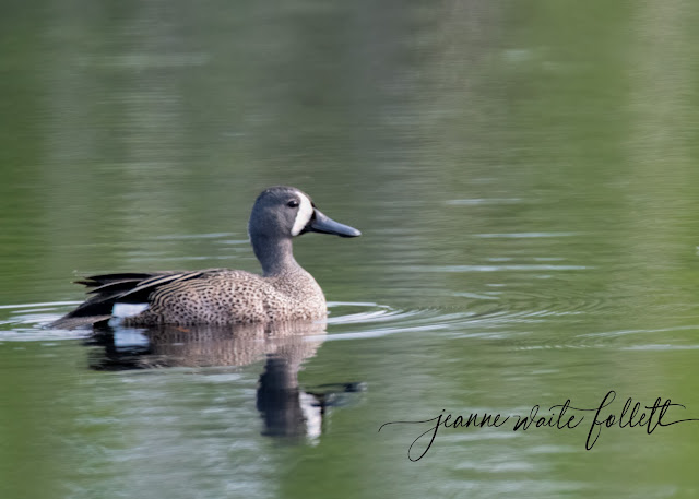
  And in the same lake, a blue-winged teal, another rare bird for us.


After leaving the lake, we soon found the construction projects and  waited our turns for the pilot cars.   The construction is pretty interesting as, in the first project, they have quarried a massive amount of rock from a cut in the alignment.   They are still drillinig and blasting for  more material.


Note the big yellow excavator loading the huge rock trucks.


 The construction areas wore me out.   That and just a couple hours sleep the previous two night.   I was really happy when we finally reached Paxson, about a hundred miles from Glennallen, and made the left turn onto the Denali highway.


Map from Glennallen to Paxson 


 The first 22 miles of the Denali highway is paved.   After that, it is chip sealed.   Not exactly pavement, but a hard, dust-free surface that is a joy to drive considering the previous times I've been over it when rain made the gravel a pot-holed and wash-boarded surface.


We did a lot of birding on the way to Maclaren River Lodge, about Mile 40, but for this episode I am taking you straight to the lodge where we will stay two nights. 


Maclaren River Lodge.


I was in the second room from the right in these duplex cabins.

The lake in front of the cabins.


My upstairs neighbor is building a nest out of little balls of med it forms and carries.   There are little balls of mud all over the deck and the two chairs that are on the deck.


I always called them mud swallows, but their name is cliff swallow.

The swallows are relentless in their nest-building.   I lay in bed that night and watched their shadows on the curtains until I fell asleep.


Next up:   Birding the Denali highway.

Thursday, June 23, 2022

Denali Highway Road Trip, 2022


 Below is a map of the major highway system in Alaska.   As you can see, we have a paucity of roads in a huge state.

 It took me all day Monday, June 13, to get ready for my annual trip to the Denali highway, illustrated in brown in the center of the map below.   My friend Leilani, and Carrie, her visitor from Florida, planned to drive to Paxon on the east end of the Denali highway, and drive through to Maclaren River Lodge, at aboout Mile 40 of the 130 mile road.

It took me all day because I kept losing things that were on their way to being packed but somehow never made that final destination.   In fact, my new Wingspan binoculars, the ones I bought to replace the previous pair that apparently fell off or out of my kayak into Tern Lake,  not only never made it to Packing Central, which is what I call the spare bedroom when I'm preparing for a trip, but still have not revealed their whereabouts.

 The first leg of the trip, for me, was to drive about 150 miles to Palmer where I would overnight at Leilani's.


May be an image of map and text that says 'ELLIOT HIGHWAY TANANA MANLEY CIRCLE DALTON HIGHWAY STEESE HIGHWAY CHENA HOT SPRINGS CHENA SPRINGS ROAD NENANA FAIRBANKS PARKS HIGHWAY NORTH EAGL DENALI HEALY DELTA DENALI NATIONAL PARK TAYLOR HIGHWAY ALASKA CHICKEN HIGHWAY CANTWELL HIGHWAY WORLD HIGHWAY PETERSVILLE ROAD PARKS HIGHWAY GLENN HIGHWAY TALKEETNA PAXSON RICHARDSON HIGHWAY TRAPPER CREEK TALKEETNA MENTASTA SLANA CHISTOCHINA GAKONA WILLOW HATCHER PASS HOUSTON WASILLA LOUISE TOLSONA GLENNALLEN COPPER KENNY CHITINA KENNICOTT MCCARTHY EUREKA PALMER TONSINA HIGHWAY VALDEZ KENAI SPUR HOPE ANCHORAGE ROAD NIKISKI HOPE EDGERTON HIGHWAY MCCARTHY RICHARDSON WHITTIER HIGHWAY SEWARD SOLDOTNA COOPER KASILOF LANDING CLAM GULCH NINILCHIK ANCHOR HOMER STERLING SEWARD CORDOVA COPPER HIGHWAY'


On the map, look at the Seward highway shown in blue and the town of Seward.   Follow that road up to where it makes a sharp westward turn that leads to a black dot.    That is approximately where I live.

So, my journey began at that point, went through Anchorage where it joined the green Glenn highway and paused overnight in Palmer.

 Contrary to what some think, we were not going to Denali National Park.   For that trip, it's best to drive up the Parks highway (maroon on the map) and the Parks highway was not named for the national park, but for George Parks who was Alaska's first resident territorial governor back in 1925-1923.

However, the Denali highway WAS THE ONLY road to get to the Park up until the Parks highway was built in the early 1970s.   Except, you could always go by the Alaska Railroad.    Needless to say, the park did not have nearly the amount of visitors back then.


Now, the Denali highway is a scenic 130-miledrive through tundra south of the Alaska Range of mountains and northwest  of the Wrangell mountains.   There are lots of hiking trails and fishing spots, but few, very few,  accommodations.   No gas stations, except you can buy gas at Maclaren River Lodge, no B&Bs, until you're almost at the western end near Cantwell.

The first 22 miles are paved.   The rest is hard-surfaced with chip sealing.   Much, much better than it old gravel road and was often pot-holed and washboarded.

Got it?


Denali, the mountain as seen from an overlook along the Parks highway.


 Before I left, however, there was a mandatory stop near my house to check on all the baby birds at Tern Lake.


The resident trumpeter swans were hatching their six youngsters.


This photo was taken recently after the eggs started hatching.   Grebes carry their young on their backs for a while.


 The red-necked grebes had five eggs that were still incubating.   So, all was well.


Three construction zones and a rock abatement project* later, I arrived in Palmer late afternoon, in time to take a few photos around this  historic agricultural area.

As for Palmer, it's located in what is called the Matanuska-Susitna Valley, so-named for the two mighty river that run through it to empty into the Knik Arm of Cook Inlet.  They neglected to mention the Knik River.


Pioneer Peak and plowed fields in Palmer.


Something interesting about Palmer:  

"In 1935, the Federal Emergency Relief Administration created an experimental farming community known as the Matanuska Valley Colony as part of the New Deal resettlement plan. Situated in the Matanuska Valley, about 45 miles northeast of Anchorage, Alaska, the colony was settled by 203 families from Minnesota, Wisconsin and Michigan. The colony project cost about $5,000,000 and, after five years, over half of the original colonists had left the valley. By 1965, only 20 of the first families were still farming the valley."    

So sayeth Wikipedia.

Tomorrow morning, Leilani will awaken us early early early and we will be on the road forever and a day until we reach Maclaren River Lodge, with multiple stops for birds and construction areas. 

***


*Rock Abatement Project is a multi-year contract aimed at eliminating rockfalls along Turnagain Arm on the Seward Highway near Anchorage.   It involves drilling, blasting, and clearing problem rock areas, as well as installing stanchions with rock-catching draped net material.   It's ugly, but if it prevents anyone getting killed with a VW-sized boulder falling on their car, all is forgiven.


Sunday, June 19, 2022

Road Trip June, 2022

 Five days, 900 miles through five construction zones and a rock abatement project twice, 1800 photos, and a little bird about four inches tall that confronted my truck and won!


And those eerie things that have happened all my life?   Happened twice.

 I am busy downloading all those photos and choosing the ones to show you.   Tune in again later!!!