"I'm going to speak my mind because I have nothing to lose."--S.I. Hayakawa
_______________________________________________________
Showing posts with label Seward Highway. Show all posts

Monday, May 2, 2022

Where am I?

 I know.   I know.  I've fallen behind on the Africa Journals.


I have a good excuse:


BEFORE: 


Jerome Lake pullout along the  Seward Highway.


AFTER:


Plus about five miles of highway ditches before the nice weather turned nasty.

Sunday, May 31, 2020

Pigs were Here!

This is that pretty pullout by Summit Lake, about Mile 45 of the Seward Highway, which is a desgnated federal Scenic Byway.    The dandelions are in bloom and out in the lake, two trumpeter swans are gobbling down underwater goodies.   You can see one of them as a white dot in the center of the photo.


I clean up this pullout every spring and then check and tidy it two or three times a week until snowfall.

Today, I discovered someone dumped three bags of household garbage.   Lots of ice cream containers, chip bags, paper plates, dryer sheets, and lint from a dryer or vacuum.  I figure the trash came from someone's home or from an RV large enough to have a washer/dryer.


And a cat.   The third bag was used cat litter.

Thursday, August 8, 2019

Some Summer Scenes along the Seward Highway

Evening at Lower Summit Lake

Afternoon at Lower Summit Lake

Tern Lake.   The two white spots in the middle are the resident trumpeter swans.

Turnagain Pass


Tern Lake with fireweed in the avalanche fan.

Saturday, December 10, 2011

The Grotto

About twenty miles south of Anchorage on the Seward Highway, which is the only highway that leads south of the largest city in Alaska, is a place known as The Grotto.  It's really just an indentation in the mountainside, overhung with cottonwood branches, with water that runs year-round down its face.

In the summer, it's a wall of small waterfalls, but in the winter it becomes an icefall wonder.

I've left the truck in the photo for size perspective.


Crammed in between the walls of The Grotto and the waters of Turnagain Arm, are the tracks of the Alaska Railroad and the two-lane Alaska Scenic Highway, National Scenic Byway, All American Road known as the Seward Highway.  Above The Grotto in the woods is an historic trail that once saw dog teams running back and forth from Seward to Anchorage.

The Grotto has been such a favorite place along this stretch of scenic road that when construction projects up-graded the highway some years back, protection of The Grotto was deemed important.  The Grotto lost some of its depth, but it's still there.


A mile north, Dall sheep roam across the mountain, often coming right down to the shoulders of the highway as more traffic than this road was ever designed for whizzes past.


Something needs to be done to improve safety along the highway, and many suggestions have been offered.  Other than declaring a portion of the highway as a  safety corridor with double traffic fines, no realistic, affordable solution has been implemented thus far.  Most of the accidents along here tend to be head-on collisions, indicating the scenery itself might take a driver's attention away from the road.


Since its completion in 1951, The Grotto has charmed thousands of people in both summer and winter.


The huge waist-high piles at the base is ice that lost its grip and fallen.


In 1778, Sailing Master William Bligh, he who would later become notorious because of a mutiny aboard his Bounty, sailed past this area in a small boat while Captain James Cook waited in deeper waters on the Resolution.  Bligh, having already explored the northern fork of the inlet that would be named after Cook,  determined (erroneously) that this southern fork also was the mouth of a large river and that they must "turn again" in their search for the fabled Northwest Passage.

A century later, explorers of a different kind traveled this area.  They were known as prospectors and a minor gold rush resulted in small settlements throughout the area.


Today, The Grotto enchants many who drive past oblivious to the history of the area.  They head to the ski slopes of Alyeska Resort, the saltwater and rivers of the Kenai Peninsula, rich in salmon and trout and halibut, and the clam beds of the inlet itself.

Friday, July 29, 2011

"Thank you."

A dozen miles north of Seward, the highway crests a large hill known, appropriately, as Mile 12 Hill and then descends in a mile-long sweeping “S” curve to the spruce and cottonwood-forested floodplain of Snow River.  It crosses a low boggy area and then rises again on a man-made overpass over the tracks of the Alaska Railroad at Mile 14.


Driving down Mile 12 hill.


Off to the right, the red steel girders of a picturesque railroad trestle span the river, the kind of trestle not seen much anymore.  Downstream of it is a large open area, formerly a materials pit from which gravel for highway construction had been extracted. 


At the apex of the overpass, the eye is drawn to this area, not to the mountains behind it that run parallel to the highway across the narrow valley.  Instead, attention is focused on a mound of screened gravel, perhaps twenty feet high and three times that long.  More specifically, attention is focused at the base of that mound.

This is an "after" photo.

That was my destination. A gray overcast that had brought rain for several days was surrendering to a late afternoon sun, leaving remnants of clouds clinging to the mountains. 

I turned off the highway onto a narrow one-lane road that led to the double arms of a locked gate. The railroad had posted a “No Trespassing” sign on this gate.  I parked, gathered my gear, and ducked under the gate.  I was pretty sure nobody would protest my trespass.


Reaching the base of that pile, I surveyed the task ahead of me.  I pulled a folded yellow litter bag from my waist pouch and flapped it open.  Then I began at one end of the mound and worked my way across its face, picking up the detritus of sportsmen without consciences.


For some years this site has been used as an unofficial firing range and bore the evidence of such.  Discarded ammo boxes, plastic cartridge holders, telephone books, plastic bottles, aluminum cans, cardboard boxes, pieces of plywood, a tire, a microwave oven, and other impromptu targets were scattered around the area.  All of it pocked with multiple bullet holes.  From the highway it looked like a garbage dump.


After working two hours in the still, hot afternoon, I’d filled eight bags with litter and stacked them out of the way so they too wouldn’t be used as targets.  I was picking up more litter as I walked back to my truck when an errant breeze brought the mist of a soft summer shower to my skin.

I looked in the direction from where the moisture had come and there, against a low ridge, was a full arched rainbow.


I acknowledged the message.

The rainbow with the railroad trestle on the right.


“You’re welcome,” I said.


Tuesday, July 19, 2011

Wherefore Wert Thou, Carmageddon??? Right Time, Wrong Place


So the much-feared Carmageddon never materialized in Los Angeles last weekend, huh?   I can tell them why:  They had the location wrong by about 2400 miles.

You know what Carmageddon was, don’t you?  The 405 freeway was closing for the weekend for maintenance and the LA powers that be expected massive traffic jams—more massive than LA’s legendary traffic jams already are.  So, they scared the bejesus out of everyone and things went well.  Not with a bang, but a whimper.

The 405 even opened well ahead of its schedule Monday morning opening.

As I said, they had the location off by 2400 miles.  Carmageddon happened, all right.  It happened right down the highway from me at Tern Lake.


They never realized Carmageddon wouldn't be in LA, but right here at sleepy Tern Lake.

This is how the perfect storm of conditions collided over a peaceful, shallow little lake where the terns and ducks and gulls are raising their young.

When you leave Anchorage and head south, you have one choice of route—the Seward Highway.    About ninety miles south, you reach a triangular-shaped junction where the Sterling Highway meets the Seward Highway.


Junction coming up.  Straight ahead to Seward; right to the southern Peninsula.

At the top end of this junction, there’s no problem.  Traffic heading for Moose Pass and Seward continues straight down the hill on the Seward Highway.   Traffic heading for Cooper Landing, Kenai, and Homer veers off to the right on a one-lane road to the Sterling Highway.   No stops, no merges, no nothing.  And certainly no traffic lights.  Just keep cruising’.


See?  Seward straight, Home right.

Traffic going back to Anchorage, however, drives the Sterling Highway along the shore of Tern Lake and comes to a stop sign at the Seward Highway.  Just a stop sign.  Look left for traffic coming down the hill from Anchorage, right for coming from Seward, then make a left turn and you’re on your way to Anchorage with no traffic control until you reach the city.


The two white vehicles at the right are waiting to make a left turn and follow the black truck up the hill towards Anchorage.  The white SUV in the center in coming from Anchorage, heading towards Seward.


Most of the time, it works just fine and the lower part of the junction is quiet and almost sleepy.
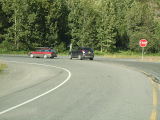

Wait for traffic, make a left, head for Anchorage.

Then comes that perfect storm I mentioned before.

Imagine this:  a weekend; absolutely spectacular weather; low tides for clam digging; the fabulous Kenai River and Kailof River dipnet fisheries were open; and, a more than a quarter million salmon leaving Cook Inlet and swimming en masse up the Kenai River—right into the waiting nets of all the folks standing waist deep in cold water holding onto fifteen foot long poles with a huge net strung on a hoop at the end of that pole.

They say you couldn’t miss.  They report multiple catches in one net.  They claim one woman caught five red salmon at one time.

Add the final ingredient:  all those people heading home.  All those people driving up the Sterling Highway on the narrow two lane highway through Cooper Landing and reaching the junction with the Seward Highway.  Each vehicle had to stop, look left and right, wait for all the traffic leaving Seward after a weekend of touring, hiking, fishing for silver salmon, halibut, and rockfish, plus all the traffic coming down the hill and heading to Moose Pass and Seward.

Add in  all the delivery trucks, the fuel haulers, the cruise boat busses, the normal everyday traffic of back and forth, the motorhomes and campers and fifth wheel trailers, trucks pulling boats, the drive-by tourists, the mountain bikers and hikers heading home after communing with mountains and mosquitoes.

What happens????

Carmageddon at Tern Lake is  what happens.   Miles and miles of vehicles backed up waiting to make that one-lane left turn onto the Seward Highway.  All the way back ten miles to Cooper Landing, some swear.  For four days it was like that.

Then, Sunday, the State Troopers came to the rescue.  In bright yellow safety vests, the troopers directed traffic, allowing those left turns more frequently than usual.  

Mid-Sunday afternoon and the troopers, whose vehicles are parked at right, have the traffic jam well under control.  They're just allowed a long line of vehicles to make that dreaded left turn, holding up traffic heading for Seward, which  usually has the right of way.


Carmageddon died Sunday afternoon, thanks to the troopers.  ‘Bout the same time the 405 opened ahead of time in LA.


Tuesday, February 8, 2011

Knock, knock, knockin' on Heaven's door...

The two lane paved road that cuts off the Seward Highway and travels the southern shore of Turnagain Arm  to the small enclave of Hope has a posted speed limit of 50 mph.  When the road is plowed and sanded, it's possible to drive that fast comfortably, even in winter.


Most of the time I see sights like this.


Last week, however, wet snow and warm temperatures slowed my drive.  That night, freezing temperatures froze the road surface into a solid, 19 mile long sheet of ice.


 Then Mother Nature's Zamboni came along and watered the ice, and the few vehicles that braved these conditions were creeping along at 25 mph.  Me especially.


Today I was back to 50 mph, until I reached the section directly along the Arm.  Then I had to stop and take pictures of dark storm clouds, an out-going tide rushing towards Cook Inlet, Chinook winds picking up saltwater spray from the white caps, and intermittent sun hitting the mountains across the waters.


Near the road's junction with the main highway, is this avalanche.


 Click on the picture, then click again when it enlarges and you can see the channels and patterns carved into the snow by tumbling snow.

There's something else, though, that slows me down on the Hope road.


See that little black spot there in the middle?


Or these?  They're pine grosbeaks or cheery little redpolls, and something else I haven't been able to get close enough to identify, pecking at the sand the highway guys spread on the road.  Sometimes they fly away when they see this maroon Honda Pilot coming their way.


But most of the time they love to wait until the last possible second, then fly up in a flurry of gray fluff while I  hold my breath and pray I don't hit any of them.


Then there's Summit pass on the Seward highway, and the sun playing on the peaks..


Thirty miles along the Seward highway, I reached Cooper Landing, where I saw this guy.

 It's skunk fur, boys and girls.  Skunk.  And doesn't his beard just fit right in?

Tonight, Chinook winds are pummeling the side of my house, reminding me of lyrics...

"Knock, knock, knockin' on Heaven's door,
Knock, knock, knocking on Heaven's door..."

Oh, tomorrow's drive is gonna be fun.