The Africa Journals
Chapter 32
The smoke that
thunders
Scenes so lovely must
have been gazed upon by angels in their flight.
—Dr. David
Livingstone, missionary/explorer, regarding Victoria Falls
There’s been a lot of water over the falls and under the bridge
since Dr. Livingston first saw the free-fall of a magnificent sheet of water he
named for the queen of England, in the way of explorers everywhere who ignored
the indigenous people’s name of Mosi-oa-Tunya,
or “The Smoke that Thunders.”
 |
| Yep, it's crooked. I took it when I was in a helicopter. |
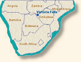
Above Victoria Falls, the Zambezi River flows slowly and
gently on its 1600 mile long task of draining a south-central portion of Africa,
slowed down by a basalt plain that drops only 590 feet in elevation over a 500 mile length, and joined
by other waterways until the Zambezi is more than a mile wide. It passes through six countries on its
journey to the Indian Ocean: Zambia, Angola, Namibia, Botswana, Zimbabwe, and
Mozambique.
The great and small animals and creatures of Africa roam it shores, the elephants and hippos and multitude of antelope join with hundred of avian species, all deriving sustenance from the life-giving waters.
Near the point where the
borders of Botswana, Namibia, Zimbabwe, and Zambia meet, the river has spent
ages carving through a fault in the basalt plateau and soft sandstone cracks to
create one of the seven natural wonders of the world: Victoria Falls and the zigzagging chasms
below it.
The river is 5604
feet wide when it plunges 354 feet to the rocks below in the first Gorge, and its sudden fury casts up a spray more than a
thousand feet high, sometimes as a misty inverse rain and sometimes as a heavy downpour, so dominant on the landscape that it is visible 30 miles away and all who look upon it think the land is on fire.
Now
severely constricted in a gorge 200 to 400 feet wide and boiling angry, the
waters rush from both sides, forming a violent whirlpool called the Boiling Pot,
where it discards much of the debris and bodies (animal and human) that
have gone over the falls. It finds escape
through a narrow neck only 360 feet wide and pours into the Second Gorge.
More than a hundred
years ago, a gang of men assaulted the Second Gorge with pre-fabricated
steel girders and arches shipped from England through Mozambique. Working under the unrelenting heat of the African sun over a tumultuous
river teeming with crocodiles, the final length was lowered into place….and
found to be six inches too long. Dismayed,
the confused engineers returned to their plans to find their mistake.
 |
| Note the bungee jumper hanging from the bridge. |
But first, they
decided a beer was necessary after the extreme heat of the day and the crushing
disappointment. One beer led to many
more and then nightfall.
When the discouraged
engineers and construction men met at the bridge the next morning to search for
a solution, they found the span had contracted in a cooling overnight rain and
had fallen neatly into place, a perfect fit.
Six hundred and fifty feet long
and 420 feet above the river, the bridge united Zimbabwe and Zambia.
 |
On that bridge today are
railroad tracks, a narrow highway lane, and a bungee jumping platform.
|
Thence, the river continues
its troubled flow through four more gorges, much to the delight of river
rafters and kayakers who lust after Grade 5 white water.
My visit to the falls
centers around the First and Second gorges, both on land and above it. Our first outing in the town of Victoria Falls,
we go to the national park for a walk along the edge of the First Gorge,
immediately opposite the falls.
 |
| Looking for lunch in all the wrong places. |
 |
| Nope, nothing there. |
 |
| This shows a narrow section of the First gorge. |
 |
| Devil's Cataract. |
 |
| Devil's Cataract. |
 |
| Now you see it... |
 |
| Now you don't... |
 |
| Danger Point, adjacent to the gap where the river flows from the first Gorge. |
 |
| Below the rock at right is where the roiling water rushes through a narrow neck into the Second Gorge. This is Danger Point, number 15 on the illustrated map. |
 |
| Danger Point and slippery, slippery rocks. |
 |
| Others at Danger Point. |
 |
| The bridge through a water-spotted lens. By the time we reached this point, I was soaking wet. |
|
|
|
|
|
|
|
 |
| A flower in the rainforest adjacent to and created by the falls. |
 |
| A busy dung beetle. |
 |
| The falls and the first gorge, and under the mist at left, white water and debris in the Boiling Pot. Follow the road at left above the blue roofs, and it leads to the bridge over the Second Gorge. |
 |
| The gap as seen from the bridge. |
 |
| Victoria Falls Hotel and its proximity to the falls. |
 |
| The red roof in the center bottom is part of Victoria Falls hotel. This photo shows the rainforest created by the water from the falls, through which we walked and where most of my photos were taken. |
For aerial video of the falls see:
http://www.airpano.ru/files/Victoria-Falls-Zambia-Zimbabwe/2-2
 |
| This photo from Wikimedia commons was taken during the low water months. It shows the narrow gap through which the water pours into the Second Gorge. At the upper left point of the gap is Danger Point. |
|


WOW JEANNIE!!!!! How impressive is that? I felt the mist from the falls just looking at your photos, what power, and powerful photos.
ReplyDeleteThanks, Irene
Even the dung beetle is a beautiful emerald green! The falls are beyond comprehension. Thank you for the map...it really helped me orient to where you are and have been. Hugs. Patti
ReplyDeletespeechless...... You are so blessed to get to go on these trips, and we are blessed to have you as our tour guide!
ReplyDeleteFor me, this would have been the absolute highlight of the trip.....or any of your trips. I've seen photos before but these are incredible. Thank you.
ReplyDeleteThanks a million, Gully!!!!
ReplyDeleteJust began following your blog this year. Your pictures and commentary are incredible. I can no longer travel, yet your African blog makes it seem as if I have been there.
ReplyDeleteWelcome to my safari. Glad to have you here.
DeleteWhat more can one add to the above .. LOVE LOVE LOVE the MAPS. Without the MAPS we would not have been able to even begin to comprehend the size of the falls. Being a civil engineer who pursued construction for most of my career I can well understand the engineers who found the 'arch key' section to be 6-inches too long. Those in-the-field always scream about those designers in-the-office designing things! Then their satisfaction the next morning after the night air had cooled the other sections and the 'arch key' fit perfectly.
ReplyDeleteAWESOME THESE VICTORIA FALLS .. Cap and Patti ..
Couldn't do the maps while I was in the cove. Had to get home to my own printer and scanner.
Delete